Insurance industry data show that damaging flood events in Aotearoa New Zealand have increased in number since the late 20th century. Many of our coastal communities are fully aware of this shift having experienced waves crashing high over storm walls, sea water flooding houses, and rocks flung across key access roads. Climate change and sea level rise will only increase the frequency of these coastal flooding events.
For many parts of our coast only small amounts of sea level rise turn today’s rare events into common ones. For example, a 30 cm increase in sea level around our capital city coastline means that a flood that today might occur once every century, will happen every year. Knowing when these thresholds will be reached and crossed is key as we work hard to adapt to unavoidable change.
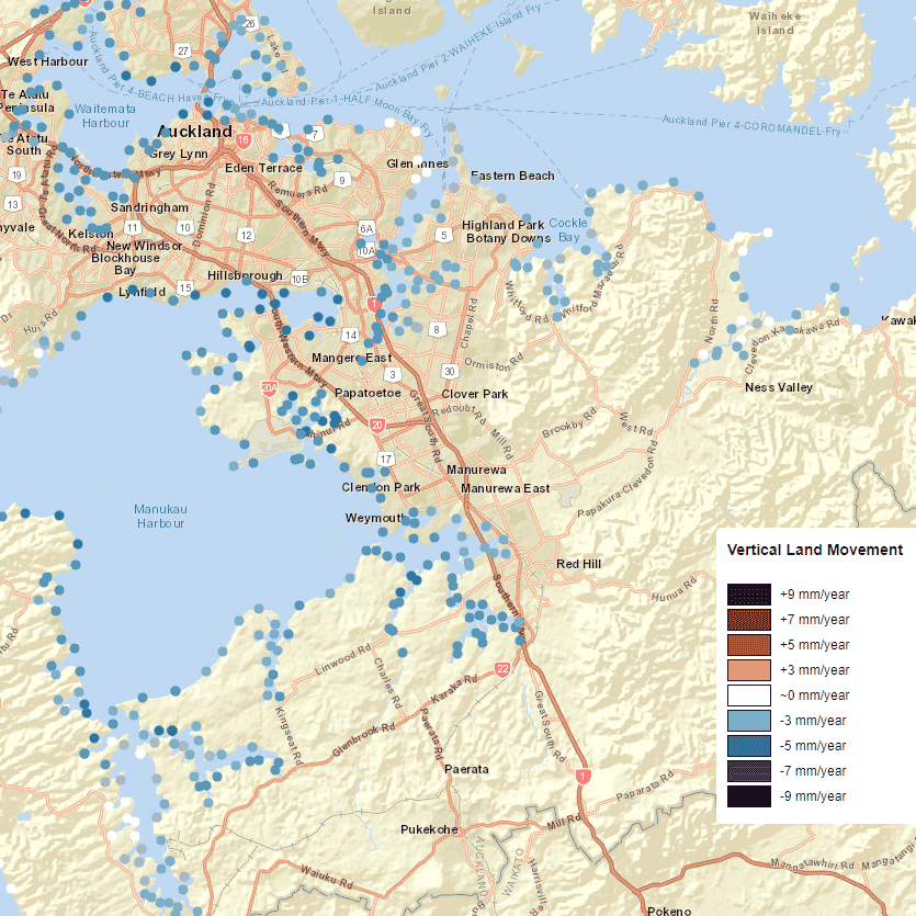
New science has shown that, for many regions of Aotearoa New Zealand, sea level is rising faster than we thought due to the influence of land subsidence. We are all very aware that our land can rapidly rise or drop in large jumps during earthquakes, but less obvious to us all is that smaller shifts occur continuously in between large seismic events. Tectonic forces are slowly pulling down the southern and eastern margins of the North Island and northern regions of the South Island and land subsidence rates are high.
Ground water extraction can also cause our land to sink and soil compaction can lower the height of the ground. These small but continuous changes add up, and in areas that are going down the annual rate of sea-level rise can double. In regions that are sinking, important thresholds will be reached within the next several decades. A total rise of 30 cm above 2005 levels may occur in parts of Wellington within the next 20 to 30 years. Of course, sea level rise will occur more slowly along regions of our coast that are rising.
If an angry sea surges against a coastal road or bridge, the decision whether to build a seawall to control the onslaught or whether to move further inland can be difficult, but it’s even more complex when the sea threatens places with deep histories of belonging. Knowing how much time we have to make these decisions is key.
Now there’s an online map giving location-specific sea-level rise projections out to the year 2300 for every 2km of the coast of Aotearoa. The aim of the map is to help our communities, from property developers to local councils to neighbourhood organisations, to understand the scale and urgency of the sea-level challenge. Property owners, councils, infrastructure providers and others need to know how sea-level will change in the coming decades so that they can consider how risks associated with flooding, erosion and rising groundwater will shift.

Sea-level rise projections for the entire coastline will help us make better decisions about how to adapt to rising seas. The new projections are being incorporated into the next Ministry for the Environment guidance for local government practitioners on coastal hazards and climate change.
Take a good look at the sea level projections tool. The finance and insurance sector have already been asking for the data – in part driven by the Task Force on Climate Related Financial Disclosures reporting requirements that need to be met by 2024.
NZ SeaRise is a five-year research programme funded by the Ministry for Business, Innovation and Employment Endeavour Fund. It brings together 30 local and international experts from Te Herenga Waka-Victoria University of Wellington, GNS Science, NIWA, University of Otago and the Antarctic Science Platform to improve projections of sea-level rise in Aotearoa New Zealand. The sea-level projection and mapping tool was developed by Takiwā, a Māori-owned data management and analytics platform. An update to the Coastal Hazards Guidance for Local Government on how to use the new projections for planning has been co-produced with the Ministry for the Environment.
Photo by Daniel Sinoca on Unsplash

